
The Canary Islands are Europe's most reliable winter sun. Between December and February, daytime highs on the coast sit around 20–22 °C, nights rarely fall below 14–15 °C, and the sea stays near 19–21 °C, warm enough for a swim most days. The catch is that winter here is spring-like rather than tropical: the north of each island collects cloud, the wind can be strong, and the summit of Tenerife regularly turns white with snow. For a week of warm afternoons, walking and beaches, most people base themselves on the sunny south coast of Tenerife or Gran Canaria, or anywhere on Lanzarote and Fuerteventura.
A quick answer to the questions people search for most: the Canary Islands are Spanish. They are an autonomous community of Spain lying about 100 km off the north-west coast of Africa, and geographically they sit on the African plate. Politically they are part of Spain and the European Union and use the euro. One difference matters to visitors: the islands are outside the EU VAT area, so duty-free allowances apply when you fly back to mainland Europe. Fuerteventura is the closest island to Africa, about 97 km from the Moroccan coast; Lanzarote is about 125 km away.
Winter weather, month by month
The islands sit in the path of the north-east trade winds. Those winds pile cloud against the northern slopes, which is why La Orotava on Tenerife or the north of Gran Canaria can be grey while the south coast is in sunshine. The two flat eastern islands, Lanzarote and Fuerteventura, are the driest and have the fewest rainy days.
| Month | Santa Cruz de Tenerife: high / low | Lanzarote airport: high / low | Rainy days (Lanzarote) | Sea temperature (Tenerife) | |---|---|---|---|---| | November | 24 / 18.5 °C | 24 / 17 °C | 3 | 22 °C | | December | 22 / 17 °C | 22 / 15.5 °C | 3 | 21 °C | | January | 21 / 15.5 °C | 21 / 14 °C | 3 | 20 °C | | February | 21 / 15.5 °C | 21.5 / 14.5 °C | 2.5 | 19.5 °C | | March | 22 / 16 °C | 23 / 15 °C | 2 | 19 °C |
Air temperatures are AEMET 1991–2020 averages (Spain's national weather service); sea temperatures are long-term averages for Tenerife. Sunshine runs at roughly 180–200 hours a month in December and January, climbing to more than 230 in March.
Two practical points follow from this. November and March are the warmest months of the winter season, and the sea is at its warmest in November. And January and February are the coolest: perfectly pleasant in the sun, but a jacket is needed in the evening and on any trip inland or uphill.
Practical info: Pack for three climates: beach, evening (a light jacket) and mountain (a warm layer, hat and proper shoes if you plan to go up Teide or Roque Nublo). Expect wind on the eastern islands, which is good news for windsurfers and less good for sunbathing on exposed beaches.
Tenerife: the most varied island in winter
Tenerife gives you the widest choice in one place: beach resorts in the south, the historic towns of La Laguna and La Orotava in the north, and Teide National Park in the middle. Teide is the highest point in Spain at 3,715 m, and in winter it is the main reason to visit Tenerife rather than any other island. Around a third of the caldera's precipitation falls as snow, so a clear winter morning can mean snow on the volcano and swimming weather on the coast on the same day.
The Teide cable car runs from a base station at 2,356 m to an upper station at 3,555 m. It is a weather-dependent service, so check on the morning you go. The last 200 m to the summit, on the Telesforo Bravo path, need a free permit from the national park, and the permits are released months in advance and run out. Without one, the upper station's viewpoints are as far as you go. Up there it can be well below freezing in winter: the weather station at Izaña, at 2,371 m, has recorded lows of −8 °C in January.
 Snow on Teide above the sea of clouds in February. Image: Alejandro Hg, CC BY 3.0, via Wikimedia Commons.
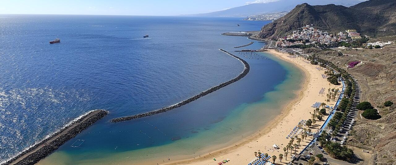
On the coast, the south-west around Los Cristianos, Costa Adeje and Los Gigantes is the sunniest and most sheltered part of the island. Los Gigantes is named for the sea cliffs that drop straight into the Atlantic there, and boat trips from the marina run year round when the sea allows. Playa de Las Teresitas, the golden beach near Santa Cruz in the north-east, is a short drive from the capital and much less built up.
 The Los Gigantes cliffs on Tenerife's west coast in mid-December. Image: Diego Delso, CC BY-SA 3.0, via Wikimedia Commons.
Practical info: Tenerife has two airports: Tenerife South (most holiday flights) and Tenerife North near La Laguna (mainly inter-island and mainland flights). Base yourself in the south-west for guaranteed sun; add a night in La Orotava or La Laguna if you want the old towns. A hire car is the easiest way to reach Teide; the park roads can close briefly after heavy snowfall. More on the island: Tenerife.
Gran Canaria: dunes in the south, a city in the north
Gran Canaria is round, mountainous and has a sharp north–south split: the north is cooler and the south warmer and sunnier. Most winter visitors stay in the south, around Playa del Inglés, Maspalomas and Puerto de Mogán. The Maspalomas Dunes, between Playa del Inglés and the Maspalomas lighthouse, are a protected nature reserve and the island's best-known landscape; walk them early or late in the day, keep to the marked paths and expect wind.
 The Maspalomas Dunes nature reserve on Gran Canaria's south coast. Image: Marc Ryckaert (MJJR), CC BY 3.0, via Wikimedia Commons.
The capital, Las Palmas, is the best city base in the Canaries for people who don't want a resort. Its Las Canteras beach, a protected area right in the city, has a natural reef that calms the water, and a long promenade lined with places to eat. The interior climbs to almost 2,000 m: Pico de las Nieves reaches 1,949 m and the Roque Nublo monolith, about 80 m tall, stands on the central plateau. Inland areas see the occasional frost or snow, so dress for it if you drive up.
 Las Canteras beach in Las Palmas de Gran Canaria at dusk. Image: Nicolas Vigier, CC0, via Wikimedia Commons.
Practical info: Gran Canaria airport is on the east coast, between Las Palmas and the southern resorts, and buses run to both. Choose the south for beach weather, Las Palmas for city life. A day trip to Roque Nublo is a classic winter walk; go early, as the car parks fill. More: Gran Canaria.
Lanzarote: volcanoes and very little rain
Lanzarote is the driest of the main islands, with around three rainy days a month in winter, and the most distinctive to look at. Between 1730 and 1736 a series of eruptions created 32 new volcanoes along an 18 km line and buried about a quarter of the island in lava. That landscape is now Timanfaya National Park. The whole island has been a UNESCO Biosphere Reserve since 1993.
 Volcanic cones in Timanfaya National Park, formed by the eruptions of 1730–1736. Image: Nikodem Nijaki, CC BY-SA 3.0, via Wikimedia Commons.
Much of what visitors come to see on Lanzarote was shaped by the artist and architect César Manrique (1919–1992), who argued for low, white buildings and turned volcanic sites into visitor attractions, Jameos del Agua among them. It is a lava tube with a salt-water lake that is home to a tiny blind crab found almost nowhere else. In La Geria, vines grow in pits 4–5 m wide dug into the volcanic ash, each with a low stone wall against the wind. The bodegas along the road through the valley sell the local wine.
 Vines planted in sheltered pits in the volcanic ash of La Geria, Lanzarote. Image: Nikodem Nijaki, CC BY-SA 3.0, via Wikimedia Commons.
Practical info: Lanzarote's airport, named after César Manrique since 2019, is just outside Arrecife. Puerto del Carmen, Playa Blanca and Costa Teguise are the main resorts; Playa Blanca is the most sheltered from the wind. Timanfaya is visited by road and on the park's coach route; walking on the lava fields is restricted. More: Lanzarote.
Fuerteventura: the beach island
Fuerteventura is the second-largest of the Canaries at about 1,660 km², and the beach island: it has the longest white-sand beaches in the archipelago, and about 150 of them in all. It is also the windiest, which is why Corralejo in the north and the Playas de Sotavento on the Jandía peninsula draw windsurfers and kitesurfers from all over Europe.
 The sand dunes of Corralejo in the north of Fuerteventura. Image: Benjamín Núñez González, CC BY-SA 4.0, via Wikimedia Commons.
The Corralejo dunes run right down to the sea next to the town of Corralejo, which is also where ferries leave for Lanzarote and the tiny island of Lobos. In the far south-west, Cofete beach is one of the wildest in Spain: a long, empty strand below the Jandía mountains, reached by a gravel road. It is beautiful and dangerous; the currents there make swimming unsafe.
 Cofete beach on the Jandía peninsula, seen from the mountain path above it. Image: JensKunstfreund, CC BY-SA 4.0, via Wikimedia Commons.
Practical info: Fuerteventura's airport is next to the capital, Puerto del Rosario. Corralejo suits people who want a town with restaurants within walking distance of the beach; Jandía/Morro Jable suits people who want the longest beaches. In winter the wind is the main thing to plan around: look for sheltered bays on blustery days.
The western islands: green and quiet
La Palma, La Gomera and El Hierro get a fraction of the visitors and suit walkers more than sunbathers. La Gomera, a short ferry ride from Los Cristianos on Tenerife, is the best day or overnight trip: its Garajonay National Park, a UNESCO World Heritage Site since 1986, protects one of the best-preserved laurel forests in the world, often wrapped in mist. The island is also known for Silbo Gomero, a whistled language used to send messages across its deep ravines.
 Mist drifting through the laurel forest of Garajonay National Park, La Gomera. Image: Stefan Koehler MD, CC BY-SA 4.0, via Wikimedia Commons.
Practical info: Expect cooler and wetter weather in these islands' forests than on any beach; bring waterproofs. La Palma and El Hierro have their own airports with flights from Tenerife North and Gran Canaria. More: La Palma and El Hierro.
Which island should you choose?
- Warmest, sunniest base: the south-west of Tenerife or the south of Gran Canaria.
- Least rain: Lanzarote and Fuerteventura.
- Best beaches: Fuerteventura.
- Best walking: Tenerife (Teide), La Gomera, La Palma.
- A real city: Las Palmas de Gran Canaria, or Santa Cruz and La Laguna on Tenerife.
- Two islands in one trip: Tenerife with La Gomera, or Lanzarote with Fuerteventura; both pairs are linked by frequent ferries.
Christmas, New Year and Carnival
Christmas in the Canaries is Spanish Christmas: nativity scenes (belenes) in town squares, midnight mass, and the Three Kings parades on the evening of 5 January, which matter more to local families than 25 December. New Year's Eve is celebrated in the town squares, where people eat twelve grapes at the twelve strokes of midnight.
The big winter event comes later: Carnival. Santa Cruz de Tenerife and Las Palmas both stage carnivals in February or early March (the dates move with Easter), with weeks of parades, costume contests and street parties. If you want to go, book accommodation in those two cities early; if you don't, avoid them on the main carnival weekends.
Tips for a winter trip
- Book the sunny side. A sea-view room on a north coast can be cooler and cloudier than the brochure suggests.
- Get the Teide permit early if you want the true summit, and check the cable car on the day.
- Hire a car on Tenerife, Gran Canaria and Lanzarote; buses cover the main routes, but the best viewpoints are inland.
- Respect the sea. Atlantic swells arrive in winter, and red flags mean no swimming; Cofete and many northern beaches are unsafe at any time.
- Remember the customs allowance if you are flying back to mainland Spain or another EU country: the islands are outside the EU VAT area.
For more on the islands, see the Canary Islands region guide and the island pages for Tenerife, Gran Canaria, Lanzarote and Fuerteventura.
.jpeg)


